
Name:
32-V32-US2135
Latitude: N37°53.104'
Longitude: W119°24.337'
Elevation: 2776m
Location: Tioga Road
GPS Accuracy: 2m
Direction: 320
Photo Date: 8/3/2008
Time: 2:15pm
Latitude: N37°53.104'
Longitude: W119°24.337'
Elevation: 2776m
Location: Tioga Road
GPS Accuracy: 2m
Direction: 320
Photo Date: 8/3/2008
Time: 2:15pm
Vale (1987) Reference: 32
Vale (1994) Reference: print
Photo Year: N/A
No
Photo Available
USGS Reference: 2135
Photographer: G.K. Gilbert
Year: 1903
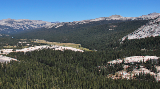
Caption: Yosemite National Park, California. Tuolumne Meadows, viewed
from a dome at the west. Other domes appear in the foreground. 1903.

Photo Credits: N.Wasserman (2008); Vale & Vale (1994). University of Utah Press; USGS
Inquires
- email the photographer